
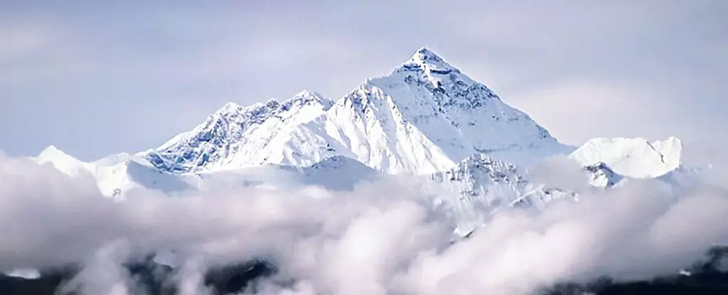
Mount Everest, or Chomolungma as it is known in Tibet, stands as an awe-inspiring symbol of the breathtaking beauty and ruggedness of the Himalayan range. Towering at a staggering 8,849 meters (29,032 feet), it invites climbers and adventurers from all over the globe to bestow their accolades upon its majestic summit. While the geological processes responsible for such monumental heights have long been studied, recent research has revealed a new angle: the phenomenon of “geological piracy.” This concept sheds light on how neighboring rivers can influence the formation and elevation of mountain peaks, with Mount Everest as a prime example, prompting questions regarding the underlying forces shaping Earth’s highest terrain.
The Tectonic Foundation
Traditionally, the geomorphology of the Himalayas has been understood primarily through tectonic plate movements. The Indian plate’s relentless collision with the Eurasian plate has forced the Earth’s crust upwards, resulting in the grandeur of the Himalayan peaks. Yet, despite the violent forces at play, most peaks within this spectacular range do not vary dramatically in height—typically within 100 meters of each other. This consistency indicates a balance of geological forces, challenging the singular notion that tectonic uplift alone can account for Everest’s exceptional stature.
This discrepancy has led scientists to investigate alternative explanations for Everest’s height. The newest research posits that geological piracy—the process whereby one river captures the flow of another—has played a significant role in the mountain’s rise. This intrusion alters sediment transport and affects how rivers carve their paths through the terrain, creating new geomorphological dynamics.
At the heart of these revelations is the Arun River, which has carved a stunning gorge in the Himalayas. This river, which flows through the region at an elevation dropping 7 kilometers over a mere 35-kilometer stretch, began a transformative journey roughly 89,000 years ago. Researchers at the China University of Geosciences and University College London propose that when the Arun captured additional water from the Kosi River, it enjoyed a hydraulic boost, empowering it to incise rock and sediment more efficiently than its neighbors.
The significance of this finding cannot be overstated: when a river captures water, it reshapes its ecosystem and surrounding geography. The process induces erosion on an unprecedented scale, stripping great chunks of the Earth’s crust away. This loss of mass can result in the upward rebound of the crust, an elastic reaction that ultimately contributes to the rise in height of nearby mountain ranges. In Everest’s case, this rebound is estimated between 15 to 50 meters and provides an intriguing layer of complexity to our understanding of the mountain’s formation.
Impact of Erosion on the Earth’s Crust
Research has shown that other rivers in the expansive Himalayan range have maintained a more stable flow pattern, leading to a consistent erosion rate at the mountains’ bases. This equilibrium, resulting from the constant erosion of geological material, prevents significant changes in the Earth’s crustal weight. However, the heightened flow and subsequent erosion caused by the Arun River capture disrupted this balance. As sediment was carried away, it allowed the Earth’s crust to uplift in certain areas—including the towering summit of Everest.
Delving deeper, researchers have modeled that this process led to an uplift rate unique to Chomolungma, with estimates of around 0.53 mm per year. Ultimately, this shows that Everest is not simply a static monument of ancient geological activity; it is an evolving landscape, continuously reshaped by both tectonic movements and the relentless power of water.
This groundbreaking study not only enhances our understanding of Mount Everest but also signifies a broader shift in geological sciences. It highlights the interconnectedness of various geological forces, illustrating how rivers can be active agents of change in mountain formation. The findings suggest that even after 89,000 years, ancient geological processes are still at work, reshaping the world’s tallest peak. As researchers continue to uncover the secrets of Mount Everest, they are likely to reveal even more intriguing stories about the dynamic patterns of our planet’s surface. Thus, Mount Everest stands not only as a remarkable achievement for climbers but also as a compelling subject for scientific inquiry and the ongoing quest to understand our planet’s complex geological narrative.
Leave a Reply