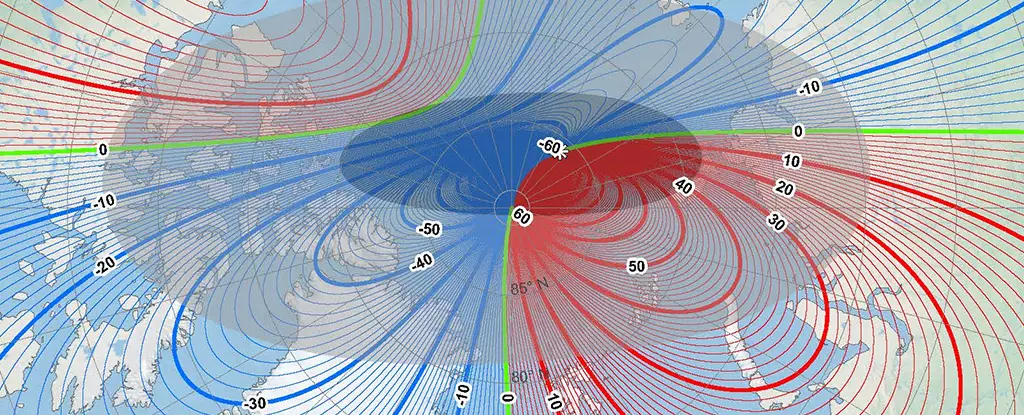
In a world that increasingly relies on precise navigation methods, the ever-shifting magnetic North Pole necessitates regular updates to navigation systems. Recent findings from the US National Oceanic and Atmospheric Administration (NOAA) and the British Geological Survey (BGS) reveal significant changes in the magnetic North Pole’s position, a phenomenon that has implications for mariners, aviators, and indeed, anyone who employs a compass. Unlike the fixed geographical North Pole—located at the Earth’s rotational axis—the magnetic North Pole is influenced by the molten iron and nickel within the Earth, resulting in constant movement. This article explores the complexities and implications of these changes.
Historically, the magnetic North Pole had been relatively stable, shifting slowly around Canadian territories since the 1500s. However, in the past two decades, this movement has intensified, with the pole racing towards Siberia at an accelerated pace. According to William Brown, a geomagnetic field modeller at BGS, the North Pole experienced a sudden deceleration from 50 kilometers per year to 35 kilometers per year—representing an unprecedented shift in its movement dynamics.
This dramatic alteration can be attributed to two significant magnetic lobes—forces of geomagnetic influence located beneath Canada and Siberia. These powerful lobes dictate not only the current positioning of the magnetic North Pole but also the nature of its movements over time. As these lobes shift, they trigger alterations in the Earth’s magnetic field, necessitating updates to magnetic models.
Importance of the Updated World Magnetic Model (WMM)
Every five years, NOAA and BGS collaborate to produce the World Magnetic Model (WMM), which acts as a crucial reference for navigation systems globally. The recent iteration of the model promises enhanced precision, boasting over ten times the detail of its predecessor. The new model presents a spatial resolution of approximately 300 kilometers at the equator, a marked improvement from the previous resolution of 3,300 kilometers.
This heightened accuracy is not just a minor technical detail—using outdated navigational models can lead to significant discrepancies. For example, a journey from South Africa to the UK could result in a navigation error of 150 kilometers (93 miles) if the old model were utilized. This realization underscores the importance of timely updates for mapping and logistics companies, governments, and navigational agencies around the world.
The Implications for Navigation and Technology
The implications of harboring outdated navigation models extend far beyond mere theoretical exploration; they affect daily operations across various sectors. For commercial aviation and shipping, which rely on precise navigational data, even slight errors can lead to costly detours and extended travel times. With the release of the new WMM, stakeholders can adjust their navigational strategies and technologies to accommodate this updated understanding.
One noteworthy aspect of this technological evolution is the automation involved; users won’t need to manually update their devices. As GPS systems worldwide automatically incorporate these changes, global navigation becomes a more streamlined and accurate process.
The magnetic North Pole first came to scientific attention in 1831 when Sir James Clark Ross documented its location in Northern Canada. Since then, advancements in measurement techniques—spanning ground observations and satellite readings—have refined our understanding of this magnetic entity. As technology continues to evolve, tracking the magnetic North Pole will only become more sophisticated, empowering researchers and navigators alike.
The future of magnetic navigation appears dynamic and robust, with the latest discoveries prompting discussions about the fundamental nature of Earth’s magnetic field. Whether for commercial purposes or holiday adventures, such as Santa’s sleigh navigations during the festive season, the importance of keeping abreast of these changes cannot be overstated.
The continuous migration of the magnetic North Pole poses unique challenges and opportunities for global navigation systems. With the latest updates from NOAA and BGS, the opportunity to recalibrate and adapt navigation methods is clearer than ever. Professionals across various fields must remain alert to these developments, ensuring that their navigational practices are informed by the most current and accurate global standards. As we prepare to navigate both the challenges and possibilities of the shifting sands of magnetism, the compass—our enduring symbol of direction—remains a vital tool in guiding us forward.


Leave a Reply